
Skeda:St Matthew's Church, Rastrick - geograph.org.uk - 77228.jpg
Nuk ka përmasa më të madhaja.
St_Matthew's_Church,_Rastrick_-_geograph.org.uk_-_77228.jpg ((përmasa 640 × 480 px, madhësia skedës: 151 KB, lloji MIME: image/jpeg))
| Kjo skedë është prej Wikimedia Commons dhe mund të përdoret nga projekte të tjera. Përshkrimi në këtë skedë në këtë faqe nuk është treguar më poshtë. | Shko tek faqja përshkruese në Commons |
Përmbledhje
This is a photo of listed building number 1183810. |
| Përshkrimi |
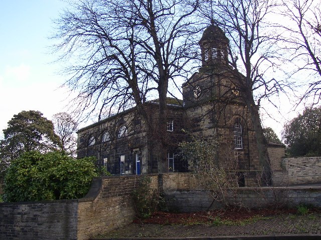
English: St Matthew's Church, Rastrick. St Matthew's Church was completed in 1798 and has a low west tower with a circular cupola over an octagonal belfry. The side towards the street has five bays with entrances in the first and last. Between these entrances are small rectangular windows set in arched surrounds in which are semi-circular windows with 'spider's web' glazing bars. Inside are three galleries on Tuscan columns. |
| Data | |
| Burimi | From geograph.org.uk |
| Autori | Humphrey Bolton |
| Atribuim (required by the license) | Humphrey Bolton / St Matthew's Church, Rastrick / |
| Object location | | View this and other nearby images on: OpenStreetMap |
|---|
_&language=sq)
Licencim

|
This image was taken from the Geograph project collection. See this photograph's page on the Geograph website for the photographer's contact details. The copyright on this image is owned by Humphrey Bolton and is licensed for reuse under the Creative Commons Attribution-ShareAlike 2.0 license.
|
Kjo skedë është dhënë për përdorim sipas licensës Creative Commons Attribution-Share Alike 2.0 Generic.
Atribuim: Humphrey Bolton
- Je i lirë të:
- ta shpërndani – ta kopjoni, rishpërndani dhe përcillni punën
- t’i bëni “remix” – të përshtatni punën
- Sipas kushteve të mëposhtme:
- atribuim – Duhet t’i jepni meritat e duhura, të siguroni një lidhje për tek licenca dhe të tregoni nëse janë bërë ndryshime. Këtë mund ta bëni në ndonjë mënyrë të arsyeshme, por jo në ndonjë mënyrë që sugjeron se licencuesi ju del zot juve apo përdorimit tuaj.
- share alike – Nëse bëni një “remix”, e shndërroni, ose ndërtoni duke u bazuar te materiali, duhet t’i shpërndani kontributet tuaja sipas të njëjtës licencë ose një të tille të përputhshme me origjinalen.
Historiku skedës
Shtypni mbi një datë/kohë për ta parë skedën siç ishte atëherë.
| Data/Koha | Miniaturë | Përmasat | Përdoruesi | Koment | |
|---|---|---|---|---|---|
| e tanishme | 30 janar 2010 21:26 | | 640 × 480 (151 KB) | GeographBot | == {{int:filedesc}} == {{Information |description={{en|1=St Matthew's Church, Rastrick. St Matthew's Church was completed in 1798 and has a low west tower with a circular cupola over an octagonal belfry. The side towards the street has five bays with ent |
Lidhje skedash
S’ka faqe që përdorin këtë kartelë.
Përdorimi global i skedës
Kjo skedë përdoret nga Wiki të tjera në vijim:
- Përdorimi në ang.wikipedia.org
- Përdorimi në en.wikipedia.org
- Përdorimi në pl.wikipedia.org
- Përdorimi në www.wikidata.org