
Skeda:Ukraine Air Boeing 737 Crashes in Southern Tehran 2020-01-08 27.jpg
Madhësia e këtij shikimi: 800 × 483 pixel. Rezolucione të tjera: 320 × 193 pixel | 640 × 386 pixel | 1.050 × 634 pixel.
Dokument origjinal ((përmasa 1.050 × 634 px, madhësia skedës: 474 KB, lloji MIME: image/jpeg))
| Kjo skedë është prej Wikimedia Commons dhe mund të përdoret nga projekte të tjera. Përshkrimi në këtë skedë në këtë faqe nuk është treguar më poshtë. | Shko tek faqja përshkruese në Commons |
Përmbledhje
| Përshkrimi |
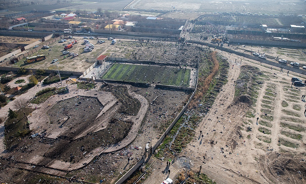
فارسی: سقوط هواپیمای اوکراینی بوئینگ ۷۳۷–۸۰۰ بین شهرهای پرند و شهریار در استان تهران
Русский: Аэрофотоснимки обломков международного авиарейса PS752 в Халаджабаде, шахрестар (область) Шахрияр, остан (провинция) Тегеран, Иран.
Обломки разбившегося Боинга 737-800 разбросаны по площади, стадиону, водотоку, дороге и другим сооружениям. Фотография иранского новостного агентства Fars.English: Aerial imagery of flight PS752 wreckage in Khalajabad, Shahriar County, Tehran Province, Iran.
Debris from the crashed 737-800 is visibly strewn across a sports pitch, waterway, and other structures. Image from Fars Deutsch: Luftbild der Absturzstelle des Ukraine-International-Airlines-Flugs 752 in Khalajabad, Bezirk Shahriar in der Provinz Tehran, Iran. Die Trümmer der abgestürzten Boeing 737-800 sind über einen Sportplatz, einen Kanal und weitere Grundstücke verteilt. Bild von Fars |
| Data | |
| Burimi | [1], direct link |
| Autori | Hossein Mersadi |
| Camera location | | View this and other nearby images on: OpenStreetMap |
|---|
Licencim
This file is from the Farsnews.ir website (or farsnews.com), which formerly stated in its footer, "Fars Media Corporation is licensed under a Creative Commons Attribution 4.0 International License." The licence is valid if files were uploaded to Commons on or prior to Feb 13, 2024 because it is the last available archived version of Farsnews website with the license declaration. This image may have previously contained a watermark, which has been removed from the image and its author and source attributed in the file page description instead. To use this image, ensure that you comply with its licensing conditions and attribute the original author appropriately.
|
This file is licensed under the Creative Commons Attribution 4.0 International license.
Atribuim: Fars Media Corporation
- Je i lirë të:
- ta shpërndani – ta kopjoni, rishpërndani dhe përcillni punën
- t’i bëni “remix” – të përshtatni punën
- Sipas kushteve të mëposhtme:
- atribuim – Duhet t’i jepni meritat e duhura, të siguroni një lidhje për tek licenca dhe të tregoni nëse janë bërë ndryshime. Këtë mund ta bëni në ndonjë mënyrë të arsyeshme, por jo në ndonjë mënyrë që sugjeron se licencuesi ju del zot juve apo përdorimit tuaj.
This file, which was originally posted to
https://media.farsnews.com/Uploaded/Files/Images/1398/10/18/13981018000416637140790600861197_49836_PhotoT.jpg, was reviewed on 10 January 2020 by reviewer Leoboudv, who confirmed that it was available there under the stated license on that date.
|
Historiku skedës
Shtypni mbi një datë/kohë për ta parë skedën siç ishte atëherë.
| Data/Koha | Miniaturë | Përmasat | Përdoruesi | Koment | |
|---|---|---|---|---|---|
| e tanishme | 10 janar 2020 19:25 | | 1.050 × 634 (474 KB) | GTVM92 | {{Information |description= |date= |source= |author= |permission= |other versions= }} |
| 8 janar 2020 14:25 |  | 1.050 × 700 (534 KB) | Hanooz | User created page with UploadWizard |
Lidhje skedash
S’ka faqe që përdorin këtë kartelë.
Përdorimi global i skedës
Kjo skedë përdoret nga Wiki të tjera në vijim:
- Përdorimi në az.wikipedia.org
- Përdorimi në bg.wikipedia.org
- Përdorimi në ca.wikipedia.org
- Përdorimi në de.wikipedia.org
- Përdorimi në en.wikipedia.org
- Përdorimi në es.wikipedia.org
- Përdorimi në fa.wikipedia.org
- Përdorimi në fr.wikipedia.org
- Përdorimi në hu.wikipedia.org
- Përdorimi në id.wikipedia.org
- Përdorimi në it.wikipedia.org
- Përdorimi në lt.wikipedia.org
- Përdorimi në nl.wikipedia.org
- Përdorimi në no.wikipedia.org
- Përdorimi në ru.wikipedia.org
- Përdorimi në ru.wikinews.org
- Përdorimi në vi.wikipedia.org
- Përdorimi në www.wikidata.org