
Skeda:Utrecht hill ridge netherlands.svg

Size of this PNG preview of this SVG file: 480 × 599 pixel. Rezolucione të tjera: 192 × 240 pixel | 385 × 480 pixel | 616 × 768 pixel | 821 × 1.024 pixel | 1.642 × 2.048 pixel | 485 × 605 pixel.
Dokument origjinal (skedë SVG, fillimisht 485 × 605 pixel, madhësia e skedës: 24 KB)
| Kjo skedë është prej Wikimedia Commons dhe mund të përdoret nga projekte të tjera. Përshkrimi në këtë skedë në këtë faqe nuk është treguar më poshtë. | Shko tek faqja përshkruese në Commons |
Përmbledhje
| Përshkrimi |
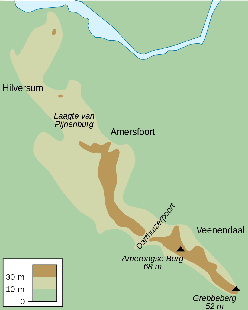
English: Map of the Utrecht Hill Ridge, a chain of hills located largely in the province of Utrecht, the Netherlands. The map shows the 10 m and 30 m contour lines, the two main peaks and the general location of several towns in the area.
Nederlands: Kaart van de Utrechtse Heuvelrug, grotendeels gelegen in de Nederlandse provincie Utrecht. De kaart toont de 10-meterlijn, de 30-meterlijn, de twee bekendste toppen en de ruwe locatie van een aantal naburige plaatsen. |
| Data | |
| Burimi | Punë e juaja |
| Autori | DennisM |
Licencim
| Unë,krijuesi i kësaj pune, e lëshoj këtë punë në public domain. Kjo aplikohet në të gjithë botën. Në disa vende kjo mund të mos jetë e mundur ligjërisht; nëse është kështu: Unë i garantoj çdokujt të drejtën për ta përdorur këtë punë për çdo qëllim, pa asnjë kusht, përveç rasteve kur këto kushte janë të kërkuara nga ligji. |
Historiku skedës
Shtypni mbi një datë/kohë për ta parë skedën siç ishte atëherë.
| Data/Koha | Miniaturë | Përmasat | Përdoruesi | Koment | |
|---|---|---|---|---|---|
| e tanishme | 25 korrik 2010 12:50 | | 485 × 605 (24 KB) | DennisM | {{Information |Description={{en|1=Map of the Utrecht Hill Ridge, a chain of hills located largely in the province of Utrecht, the Netherlands. The map shows the 10 m and 30 m contour lines, the two main peaks and the general location of several towns in t |
Lidhje skedash
S’ka faqe që përdorin këtë kartelë.
Përdorimi global i skedës
Kjo skedë përdoret nga Wiki të tjera në vijim:
- Përdorimi në en.wikipedia.org
- Përdorimi në fr.wikipedia.org
- Përdorimi në fy.wikipedia.org
- Përdorimi në li.wikipedia.org
- Përdorimi në nl.wikipedia.org
- Përdorimi në sl.wikipedia.org
- Përdorimi në www.wikidata.org