
Skeda:Wake Island.png

Madhësia e këtij shikimi: 597 × 600 pixel. Rezolucione të tjera: 239 × 240 pixel | 631 × 634 pixel.
Dokument origjinal ((përmasa 631 × 634 px, madhësia skedës: 307 KB, lloji MIME: image/png))
| Kjo skedë është prej Wikimedia Commons dhe mund të përdoret nga projekte të tjera. Përshkrimi në këtë skedë në këtë faqe nuk është treguar më poshtë. | Shko tek faqja përshkruese në Commons |
|
This is an image of a place or building that is listed on the National Register of Historic Places in the United States of America. Its reference number is 85002726. |
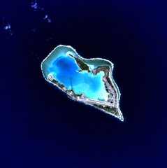
Wake Island - NASA NLT Landsat 7 (Visible Color) Satellite Image
| This file is in the public domain in the United States because it was solely created by NASA. NASA copyright policy states that "NASA material is not protected by copyright unless noted". (See Template:PD-USGov, NASA copyright policy page or JPL Image Use Policy.) | ||
 |
Warnings:
|
| Object location | | View this and other nearby images on: OpenStreetMap |
|---|
Historiku skedës
Shtypni mbi një datë/kohë për ta parë skedën siç ishte atëherë.
| Data/Koha | Miniaturë | Përmasat | Përdoruesi | Koment | |
|---|---|---|---|---|---|
| e tanishme | 10 prill 2005 17:05 | | 631 × 634 (307 KB) | Bollar | Wake Island - NASA NLT Landsat 7 (Visible Color) Satellite Image {{PD-USGov-NASA}} |
Lidhje skedash
S’ka faqe që përdorin këtë kartelë.
Përdorimi global i skedës
Kjo skedë përdoret nga Wiki të tjera në vijim:
- Përdorimi në af.wikipedia.org
- Përdorimi në als.wikipedia.org
- Përdorimi në ast.wikipedia.org
- Përdorimi në cr.wikipedia.org
- Përdorimi në da.wikipedia.org
- Përdorimi në de.wikipedia.org
- Përdorimi në en.wikipedia.org
- Përdorimi në es.wikipedia.org
- Përdorimi në et.wikipedia.org
- Përdorimi në eu.wikipedia.org
- Përdorimi në fi.wikipedia.org
- Përdorimi në frp.wikipedia.org
- Përdorimi në frr.wikipedia.org
- Përdorimi në fr.wikipedia.org
- Përdorimi në gl.wikipedia.org
- Përdorimi në hi.wikipedia.org
- Përdorimi në id.wikipedia.org
- Përdorimi në is.wikipedia.org
- Përdorimi në it.wikipedia.org
- Përdorimi në ja.wikinews.org
- Përdorimi në jv.wikipedia.org
- Përdorimi në ko.wikipedia.org
- Përdorimi në la.wikipedia.org
- Përdorimi në lv.wikipedia.org
- Përdorimi në ms.wikipedia.org
- Përdorimi në mt.wikipedia.org
- Përdorimi në no.wikipedia.org
- Përdorimi në pap.wikipedia.org
- Përdorimi në pl.wiktionary.org
- Përdorimi në pt.wikipedia.org
- Përdorimi në ro.wikipedia.org
Shikoni më shumë përdorim global të kësaj skede.