
Skeda:Winterslow Range, Canterbury, New Zealand.jpg

Madhësia e këtij shikimi: 799 × 237 pixel. Rezolucione të tjera: 320 × 95 pixel | 640 × 190 pixel | 1.024 × 304 pixel | 1.280 × 380 pixel | 2.560 × 760 pixel | 10.559 × 3.133 pixel.
Dokument origjinal ((përmasa 10.559 × 3.133 px, madhësia skedës: 20,67 MB, lloji MIME: image/jpeg))
| Kjo skedë është prej Wikimedia Commons dhe mund të përdoret nga projekte të tjera. Përshkrimi në këtë skedë në këtë faqe nuk është treguar më poshtë. | Shko tek faqja përshkruese në Commons |
Përmbledhje
| Përshkrimi |
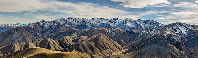
English: View from the northern slopes of Mt Somers towards the north. In the front, quite eroded Winterslow Range can be seen. In the back stands younger and less eroded Old Man Range. On the left is Mt Somers Range that connects both ranges. Canterbury, New Zealand
Español: Vista hacia el norte desde la ladera norte de Mount Somers, región de Canterbury, Nueva Zelanda. En el primer plano se ve las cumbres de Winterslow, un macizo bastante erosionado. En en el fondo surge el macizo Old Man, un macizo más joven y menos erosionado. A la izquierda se extiende el macizo de Mount Somers que conecta ambos macizos.
Magyar: Kilátás a Mount Somers északi lejtőiről észak felé nézve. Szemben látható a meglehetősen erodált Winterslow hegylánc. Hátul a fiatalabb és kevésbé erodált Old Man hegylánc. Balra a Mount Somers hegylánc, amely a két hegyláncot összeköti (Canterbury régió, Új-Zéland)
한국어: 소머스 산(테 키에키에)의 북부 능선에서 북쪽을 바라본 모습. 앞쪽에는 침식이 상당히 진행된 윈터슬로 산줄기가 보이고, 뒤로는 보다 젊고 덜 침식된 올드맨 산줄기가 보인다. 왼쪽에는 두 산줄기를 연결하는 소머스 산줄기가 있다. 뉴질랜드 캔터베리 지방.
Македонски: Поглед на венците Винтерслоу и Сомерс во Кантербери, Нов Зеланд.
Nederlands: De Nieuw-Zeelandse Alpen vormen de westelijke grens van de regio Canterbury op het Zuidereiland
Português: Vista das encostas do monte Somers, região de Canterbury, Nova Zelândia. No primeiro plano pode-se observar os cumes da cordilheira de Winterslow. Ao fundo surge a cordilheira Old Man. À esquerda se estende a cordilheira do monte Somers que conecta as duas cordilheiras
Français : Vue depuis le versant nord du Mont Somers / Te Kiekie, dans la région de Canterbury (Nouvelle-Zélande). Au premier plan, la chaîne "Winterslow", très érodée, est visible. Dans le fond se dresse la chaîne "Old Man", plus jeune et donc moins érodée. Et tout à gauche se trouve la chaîne du Mont Somers, qui connecte les deux autres chaînes de montagnes.
Čeština: Severní svahy hory Mount Somers / Te Kiekie v pohoří Jižní Alpy na Jižním ostrově Nového Zélandu.
Эрзянь: Mount Somers / Te Kiekie пелевеёнонь пандобокасто ванмось Пелевеёнксов. Икеле неяви Уинтерслоу пандокарясозь. Удало ашти седе од ды аволь яжась Old Man Range пандось. Кершёно Сомерс пандокарязось, кона сюлми кавто пандокарязтнэнь. Кентербери, Новая Зеландия. |
| Data | |
| Burimi | Punë e juaja |
| Autori | Michal Klajban |
|
This image was selected as picture of the day on Wikimedia Commons for 14 September 2020. It was captioned as follows: English: View from the northern slopes of Mount Somers / Te Kiekie looking towards the north. In the front, the quite eroded Winterslow Range can be seen. In the back stands the younger and less eroded Old Man Range. On the left is the Mt Somers Range that connects both ranges. Canterbury, New Zealand. Other languages:
Čeština: Severní svahy hory Mount Somers / Te Kiekie v pohoří Jižní Alpy na Jižním ostrově Nového Zélandu. English: View from the northern slopes of Mount Somers / Te Kiekie looking towards the north. In the front, the quite eroded Winterslow Range can be seen. In the back stands the younger and less eroded Old Man Range. On the left is the Mt Somers Range that connects both ranges. Canterbury, New Zealand. Español: Vista hacia el norte desde la ladera norte de Mount Somers, región de Canterbury, Nueva Zelanda. En el primer plano se ve las cumbres de Winterslow, un macizo bastante erosionado. En en el fondo surge el macizo Old Man, un macizo más joven y menos erosionado. A la izquierda se extiende el macizo de Mount Somers que conecta ambos macizos. Français : Vue depuis le versant nord du Mont Somers / Te Kiekie, dans la région de Canterbury (Nouvelle-Zélande). Au premier plan, la chaîne "Winterslow", très érodée, est visible. Dans le fond se dresse la chaîne "Old Man", plus jeune et donc moins érodée. Et tout à gauche se trouve la chaîne du Mont Somers, qui connecte les deux autres chaînes de montagnes. Magyar: Kilátás a Mount Somers északi lejtőiről észak felé nézve. Szemben látható a meglehetősen erodált Winterslow hegylánc. Hátul a fiatalabb és kevésbé erodált Old Man hegylánc. Balra a Mount Somers hegylánc, amely a két hegyláncot összeköti (Canterbury régió, Új-Zéland) Nederlands: De Nieuw-Zeelandse Alpen vormen de westelijke grens van de regio Canterbury op het Zuidereiland Português: Vista das encostas do monte Somers, região de Canterbury, Nova Zelândia. No primeiro plano pode-se observar os cumes da cordilheira de Winterslow. Ao fundo surge a cordilheira Old Man. À esquerda se estende a cordilheira do monte Somers que conecta as duas cordilheiras Македонски: Поглед на венците Винтерслоу и Сомерс во Кантербери, Нов Зеланд. |
| Object location | | View this and other nearby images on: OpenStreetMap |
|---|
The production, editing or release of this file was supported by the Community-Budget of Wikimedia Deutschland. To see other files made with the support of Wikimedia Deutschland, please see the category Supported by Wikimedia Deutschland. |
Licencim
Unë, krijuesi i kësaj pune, e publikoj këtu në bazë të licensës në vijim:
This file is licensed under the Creative Commons Attribution-Share Alike 4.0 International license.
- Je i lirë të:
- ta shpërndani – ta kopjoni, rishpërndani dhe përcillni punën
- t’i bëni “remix” – të përshtatni punën
- Sipas kushteve të mëposhtme:
- atribuim – Duhet t’i jepni meritat e duhura, të siguroni një lidhje për tek licenca dhe të tregoni nëse janë bërë ndryshime. Këtë mund ta bëni në ndonjë mënyrë të arsyeshme, por jo në ndonjë mënyrë që sugjeron se licencuesi ju del zot juve apo përdorimit tuaj.
- share alike – Nëse bëni një “remix”, e shndërroni, ose ndërtoni duke u bazuar te materiali, duhet t’i shpërndani kontributet tuaja sipas të njëjtës licencë ose një të tille të përputhshme me origjinalen.
Ky imazh është vlerësuar duke përdorur udhëzimet imazheve cilësore dhe konsiderohet një imazh cilësor.
|
| Annotations | This image is annotated: View the annotations at Commons |
Historiku skedës
Shtypni mbi një datë/kohë për ta parë skedën siç ishte atëherë.
| Data/Koha | Miniaturë | Përmasat | Përdoruesi | Koment | |
|---|---|---|---|---|---|
| e tanishme | 27 qershor 2019 10:24 | 10.559 × 3.133 (20,67 MB) | Podzemnik | dust spots | |
| 27 qershor 2019 10:10 | 10.559 × 3.133 (20,58 MB) | Podzemnik | User created page with UploadWizard |
Lidhje skedash
Këto faqe lidhen tek kjo skedë:
Përdorimi global i skedës
Kjo skedë përdoret nga Wiki të tjera në vijim:
- Përdorimi në arz.wikipedia.org
- Përdorimi në ceb.wikipedia.org
- Përdorimi në crh.wikipedia.org
- Përdorimi në cv.wikipedia.org
- Përdorimi në fa.wikipedia.org
- Përdorimi në fr.wikipedia.org
- Përdorimi në hu.wikipedia.org
- Përdorimi në hy.wikipedia.org
- Përdorimi në ka.wikipedia.org
- Përdorimi në ko.wikipedia.org
- Përdorimi në lbe.wikipedia.org
- Përdorimi në lez.wikipedia.org
- Përdorimi në mk.wikipedia.org
- Përdorimi në os.wikipedia.org
- Përdorimi në ps.wikipedia.org
- Përdorimi në pt.wikipedia.org
- Përdorimi në ru.wikipedia.org
- Përdorimi në ru.wikinews.org
- Përdorimi në sah.wikipedia.org
- Përdorimi në tt.wikipedia.org
- Përdorimi në vep.wikipedia.org
- Përdorimi në www.wikidata.org
- Përdorimi në zh.wikipedia.org