
Skeda:Bödele Bregenzerwald Panorama.jpg
Madhësia e këtij shikimi: 800 × 231 pixel. Rezolucione të tjera: 320 × 92 pixel | 640 × 185 pixel | 1.024 × 296 pixel | 1.280 × 370 pixel | 6.956 × 2.010 pixel.
Dokument origjinal ((përmasa 6.956 × 2.010 px, madhësia skedës: 2,4 MB, lloji MIME: image/jpeg))
| Kjo skedë është prej Wikimedia Commons dhe mund të përdoret nga projekte të tjera. Përshkrimi në këtë skedë në këtë faqe nuk është treguar më poshtë. | Shko tek faqja përshkruese në Commons |
|
| Përshkrimi |
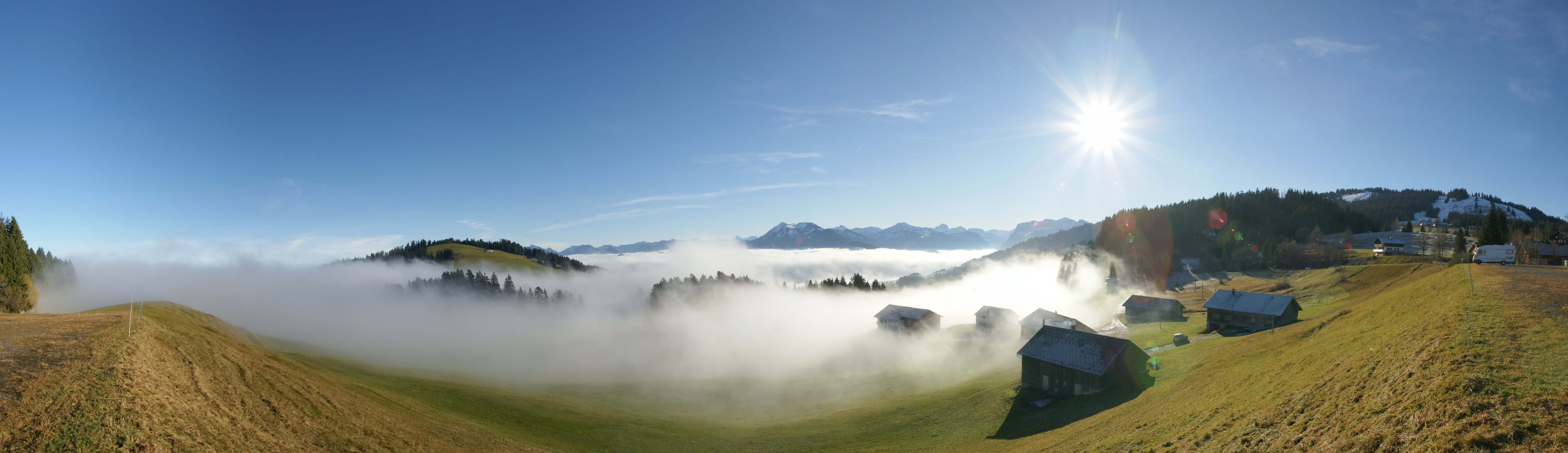
Deutsch: 180° Panorama am Bödele, gelegen zwischen Dornbirn und Schwarzenberg, Vorarlberg, Österreich. Die 2 Bergspitzen in der Bildmitte sind die Winterstaude 1877m und rechts der Hohe Ifen 2230m. Das Bergmassiv unter der Sonne ist die Nordflanke der Kanisfluh. Am rechten Bildrand zu sehen das Skigebiet Bödele mit dem Hochälpelekopf 1464m.
English: 180 ° panorama at Bödele, located between Dornbirn and Schwarzenberg, Vorarlberg, Austria. The 2 peaks in the middle are the winter Perennial 1877m and the right of the High Ifen 2230m. The mountain range under the sun is the northern flank of Kanisfluh. On the right screen to see the ski area with the Bödele Hochälpelekopf 1464m.
Français : Vue panoramique à 180 ° depuis Bödele, un village entre Dornbirn et Schwarzenberg, dans le Vorarlberg, en Autriche. Les deux sommets visibles à l'horizon au centre sont le Winterstaude (1877) et le Hoher Ifen (2230). La chaine de montagne juste sous le soleil correspond au flanc nord du Kanisfluh. Tout à droite de la photo on voit le domaine skiable culminant au Bödele Hochälpelekopf à 1464m.
|
||
| Data | |||
| Burimi | Punë e juaja | ||
| Autori | böhringer friedrich | ||
| Leja (Ripërdor këtë skedë) |
Unë, krijuesi i kësaj pune, e publikoj këtu në bazë të licensës në vijim: Kjo skedë është dhënë për përdorim sipas licensës Creative Commons Attribution-Share Alike 2.5 Generic.
|
||
| Versione tjera |
|

This Photo was taken by Böhringer Friedrich.
|
Feel free to use my photos, but please mention me as the author and if you want send me a message. or (rufre@lenz-nenning.at) |
| Camera location | | View this and other nearby images on: OpenStreetMap |
|---|
| Annotations | This image is annotated: View the annotations at Commons |
Historiku skedës
Shtypni mbi një datë/kohë për ta parë skedën siç ishte atëherë.
| Data/Koha | Miniaturë | Përmasat | Përdoruesi | Koment | |
|---|---|---|---|---|---|
| e tanishme | 21 nëntor 2008 21:32 | 6.956 × 2.010 (2,4 MB) | Böhringer | {{Information |Description= {{de| 180° Panorama am Bödele, gelegen zwischen Dornbirn und Schwarzenberg. Die 2 Bergspitzen in der Bildmitte sind die [[:de:Winterstaude|Winterstaude 1877m | |
| 17 nëntor 2008 12:34 | 6.956 × 2.010 (8,29 MB) | Böhringer | {{Information |Description= {{de| 180° Panorama am Bödele, gelegen zwischen Dornbirn und Schwarzenberg.}} |Source= own work |Date= 2008-11-16 |Author= [[User:Böhringer|böhringer fried |
Lidhje skedash
Këto faqe lidhen tek kjo skedë:
Përdorimi global i skedës
Kjo skedë përdoret nga Wiki të tjera në vijim:
- Përdorimi në bs.wikipedia.org
- Përdorimi në de.wikipedia.org
- Përdorimi në en.wikipedia.org
- Përdorimi në es.wikipedia.org
- Përdorimi në es.wikivoyage.org
- Përdorimi në et.wikipedia.org
- Përdorimi në fr.wikipedia.org
- Përdorimi në hy.wikipedia.org
- Përdorimi në mk.wikipedia.org
- Përdorimi në nl.wikipedia.org
- Përdorimi në pl.wikipedia.org
- Përdorimi në sv.wikipedia.org
- Përdorimi në uk.wikipedia.org
- Përdorimi në vi.wikipedia.org