
Skeda:Crau biome area map-fr.svg

Size of this PNG preview of this SVG file: 585 × 600 pixel. Rezolucione të tjera: 234 × 240 pixel | 468 × 480 pixel | 749 × 768 pixel | 999 × 1.024 pixel | 1.998 × 2.048 pixel | 995 × 1.020 pixel.
Dokument origjinal (skedë SVG, fillimisht 995 × 1.020 pixel, madhësia e skedës: 698 KB)
| Kjo skedë është prej Wikimedia Commons dhe mund të përdoret nga projekte të tjera. Përshkrimi në këtë skedë në këtë faqe nuk është treguar më poshtë. | Shko tek faqja përshkruese në Commons |
Përmbledhje
| Camera location | | View this and other nearby images on: OpenStreetMap |
|---|
| Përshkrimi |
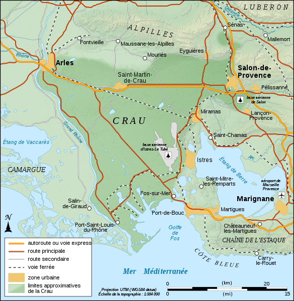
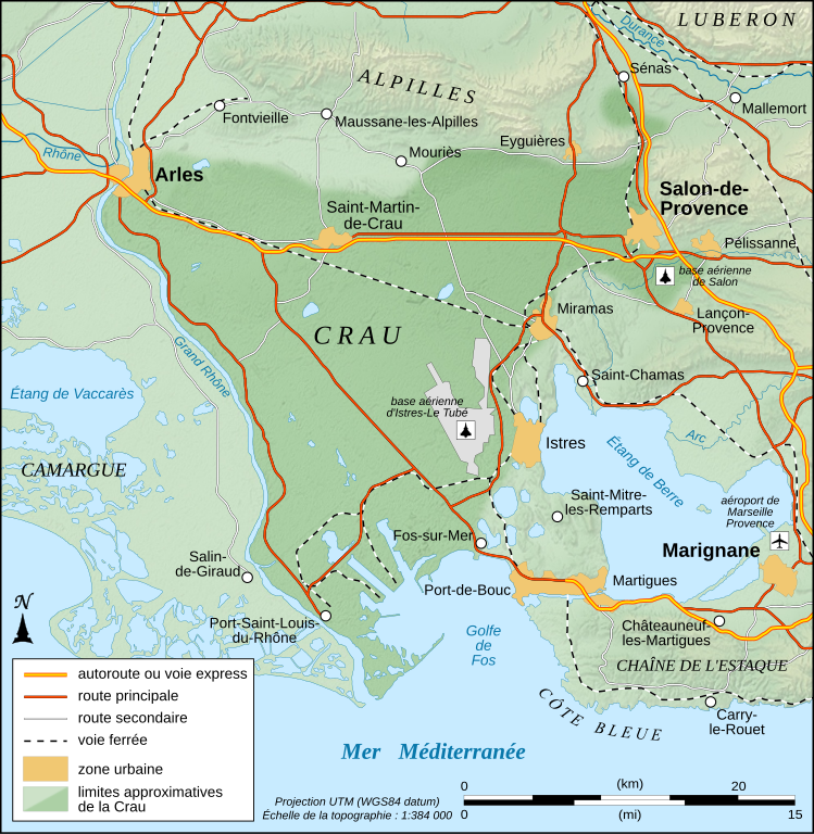
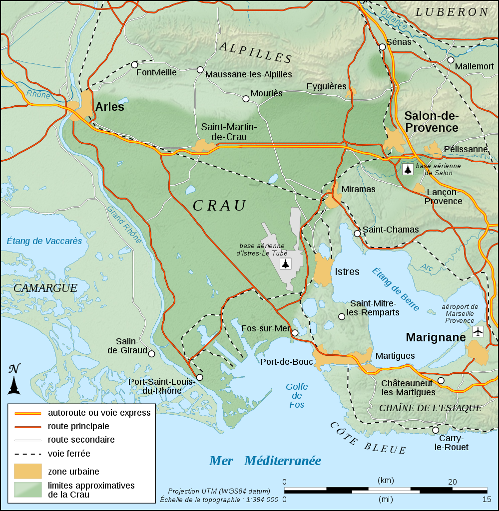
English: Physical map in French of the approximate area of Crau's biome, France.
Note: The background map is a raster image embedded in the SVG file. Français : Carte physique en français des limites approximatives du biome de la Crau, France. Note : Le fond de carte est une image bitmap embarquée dans le fichier SVG. UTM projection ; WGS84 datum ; shaded relief (composite image of N-W, W and N lightning positions) |
||
| Data | |||
| Burimi |
Punë e juaja
|
||
| Autori | Eric Gaba (Sting - fr:Sting) | ||
| Leja (Ripërdor këtë skedë) |
|

|
Kjo skedë SVG përdor tekst i cili mund të përkthehet fare lehtë në gjuhën tënde përmes [toolforge:svgtranslate/File:Crau_biome_area_map-fr.svglink këtij mjeti] në mënyrë automatike. Lexo më tepër. Gjithashtu ju mund ta shkarkoni këtë skedar dhe ta redaktoni manualisht përmes një tekst-editori. |
Licencim
Unë, krijuesi i kësaj pune, e publikoj këtu në bazë të licensës në vijim:

|
Ju jepet leje për ta kopjuar, shpërndarë dhe/ose ndryshuar këtë dokument sipas kushteve të Licencës GNU për Dokumentim të Lirë, versioni 1.2 ose çfarëdo versioni të mëpasshëm të botuar nga Free Software Foundation; pa Seksione të Pandryshueshme, pa Tekste Kapakësh të Përparmë, dhe pa Tekste Kapakësh të Pasmë. Një kopje e kësaj licence është përfshirë në seksionin e titulluar GNU Free Documentation License. |
This file is licensed under the Creative Commons Attribution-Share Alike Attribution-Share Alike 4.0 International, 3.0 Unported, 2.5 Generic, 2.0 Generic and 1.0 Generic license.
- Je i lirë të:
- ta shpërndani – ta kopjoni, rishpërndani dhe përcillni punën
- t’i bëni “remix” – të përshtatni punën
- Sipas kushteve të mëposhtme:
- atribuim – Duhet t’i jepni meritat e duhura, të siguroni një lidhje për tek licenca dhe të tregoni nëse janë bërë ndryshime. Këtë mund ta bëni në ndonjë mënyrë të arsyeshme, por jo në ndonjë mënyrë që sugjeron se licencuesi ju del zot juve apo përdorimit tuaj.
- share alike – Nëse bëni një “remix”, e shndërroni, ose ndërtoni duke u bazuar te materiali, duhet t’i shpërndani kontributet tuaja sipas të njëjtës licencë ose një të tille të përputhshme me origjinalen.
Mundeni të përzgjidhni licencën që doni.
Historiku skedës
Shtypni mbi një datë/kohë për ta parë skedën siç ishte atëherë.
| Data/Koha | Miniaturë | Përmasat | Përdoruesi | Koment | |
|---|---|---|---|---|---|
| e tanishme | 4 shtator 2008 14:33 | | 995 × 1.020 (698 KB) | Sting | Icons of the air bases |
| 20 gusht 2008 03:49 |  | 995 × 1.020 (695 KB) | Sting | Roads classification | |
| 19 gusht 2008 08:51 |  | 995 × 1.020 (695 KB) | Sting | + extend of Istres AB's area | |
| 19 gusht 2008 08:37 |  | 995 × 1.020 (694 KB) | Sting | More corrections | |
| 19 gusht 2008 08:26 |  | 995 × 1.020 (679 KB) | Sting | + 1 air base | |
| 19 gusht 2008 08:07 |  | 995 × 1.020 (677 KB) | Sting | Correction ; + airport and air base | |
| 18 gusht 2008 22:43 |  | 995 × 1.020 (671 KB) | Sting | == Summary == {{Location|43|34|00|N|04|51|00|E|scale:200000}} <br/> {{Information |Description={{en|Physical map in French of the approximate area of Crau's biome, France.<br/>''Note:'' The background map is a ras |
Lidhje skedash
Këto faqe lidhen tek kjo skedë:
Përdorimi global i skedës
Kjo skedë përdoret nga Wiki të tjera në vijim:
- Përdorimi në de.wikipedia.org
- Përdorimi në en.wikipedia.org
- Përdorimi në fr.wikipedia.org
- Përdorimi në fr.wikinews.org
- Përdorimi në fr.wiktionary.org
- Përdorimi në it.wikipedia.org
- Përdorimi në ja.wikipedia.org
- Përdorimi në nl.wikipedia.org
- Përdorimi në pl.wikipedia.org
- Përdorimi në www.wikidata.org