
Skeda:Herodotus world map-en.svg

Size of this PNG preview of this SVG file: 788 × 476 pixel. Rezolucione të tjera: 320 × 193 pixel | 640 × 387 pixel | 1.024 × 619 pixel | 1.280 × 773 pixel | 2.560 × 1.546 pixel.
Dokument origjinal (skedë SVG, fillimisht 788 × 476 pixel, madhësia e skedës: 319 KB)
| Kjo skedë është prej Wikimedia Commons dhe mund të përdoret nga projekte të tjera. Përshkrimi në këtë skedë në këtë faqe nuk është treguar më poshtë. | Shko tek faqja përshkruese në Commons |
This W3C-unspecified vector image was created with Inkscape .
| Përshkrimi |
[]
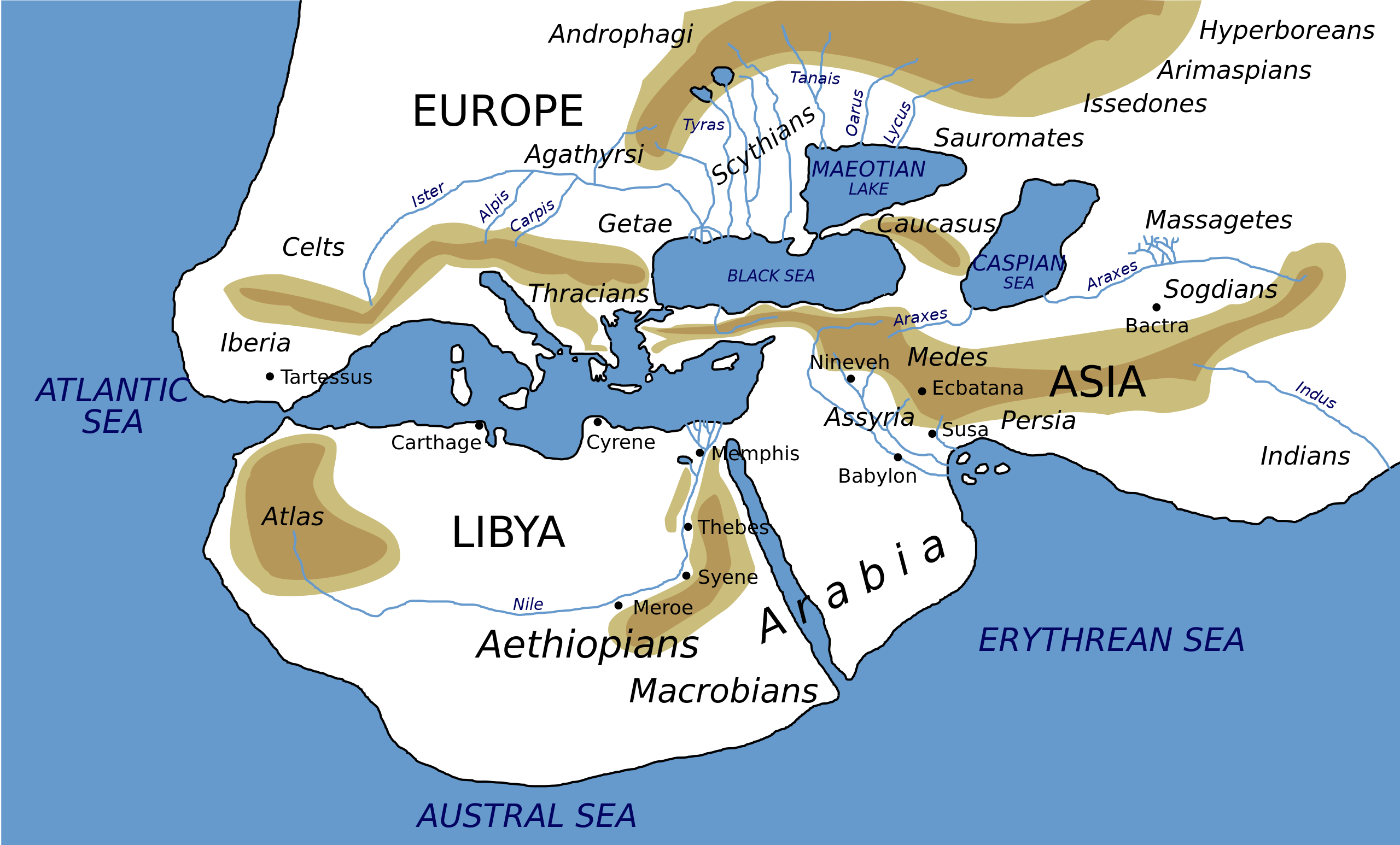
Català: Mapa del món segons Heròdot, segle V a. C. Deutsch: Mögliche Weltdarstellung nach den Historien des Herodot (5. Jahrhundert v. Chr) English: Possibly what the world according to Herodotus looked like (5th century BC). Español: Mapa del mundo según Heródoto, siglo V a. C. Euskara: Munduaren balizko mapa Herodotoren arabera, K. a. V. mendean Français : Reconstruction du monde décrit par Hérodote dans son Enquête (Ve siècle av. J.-C.). Hrvatski: Rekonstruirana karta svijeta prema Herodotu (5. st. pr. Kr.) Italiano: Carta Geografica da Herodotus Ελληνικά: Χάρτης της Οικουμένης κατά τον Ηρόδοτο, τον 5 αιώνα π. Χ. ქართული: ჰეროდოტეს მსოფლიოს რუკა ქართულად ) ไทย: แผนที่โลกที่ใกล้เคียงตามคำกล่าวของเฮอรอโดทัสมากที่สุด (ศตวรรษที่ 5 ก่อนคริสตกาล) 中文: 希罗多德笔下的世界,译名主要依照《历史》(徐松岩译) 注:唯极南的Macrobian人未能在英文维基百科中提到的3.114的英汉译本对应位置找到,只提到了埃塞俄比亚地区的人是人类中身材最为高大的,且条目中提及的防腐技术、寿命等描述也在书中对应埃塞俄比亚人。 العربية : خارطة العالم كما يُحتمل أن تصوره هيرودوت خلال القرن الخامس ق.م.. کوردی: نەخشەی جیھان بەو شێوەیەی کە ھیرۆدیۆت پێشبینی کردووە لە ( قەرنی پێنج پێش میلاد |
||
| Data | |||
| Burimi | Own work (based on the GIF by Marco Prins and Jona Lendering from www.livius.org, from http://www.mediterranees.net/geographie/herodote/cartes.html, http://www.henry-davis.com/MAPS/Ancientimages/109A.GIF). Compare this map from The Challenger Reports, 1895. | ||
| Krijues | |||
| Leja (Ripërdor këtë skedë) |
|
||
| Georeferencing | If inappropriate please set warp_status = skip to hide. | ||
| Versione tjera |
Derivative works of this file: []
|


|
Kjo skedë SVG përdor tekst i cili mund të përkthehet fare lehtë në gjuhën tënde përmes [toolforge:svgtranslate/File:Herodotus_world_map-en.svglink këtij mjeti] në mënyrë automatike. Lexo më tepër. Gjithashtu ju mund ta shkarkoni këtë skedar dhe ta redaktoni manualisht përmes një tekst-editori. |
Historiku skedës
Shtypni mbi një datë/kohë për ta parë skedën siç ishte atëherë.
| Data/Koha | Miniaturë | Përmasat | Përdoruesi | Koment | |
|---|---|---|---|---|---|
| e tanishme | 8 shkurt 2024 03:59 | | 788 × 476 (319 KB) | Manlleus | File uploaded using svgtranslate tool (https://svgtranslate.toolforge.org/). Added translation for ca. |
| 3 janar 2023 20:32 |  | 788 × 476 (325 KB) | Chiswick Chap | scale a couple of key labels | |
| 4 prill 2022 12:37 |  | 788 × 476 (315 KB) | Shapez | Reverted to version as of 08:42, 4 February 2022 (UTC) | |
| 3 prill 2022 19:23 |  | 788 × 476 (341 KB) | Shapez | File uploaded using svgtranslate tool (https://svgtranslate.toolforge.org/). Added translation for ja. | |
| 4 shkurt 2022 10:42 |  | 788 × 476 (315 KB) | Andrei Stroe | File uploaded using svgtranslate tool (https://svgtranslate.toolforge.org/). Added translation for ro. | |
| 16 maj 2018 19:45 |  | 788 × 476 (277 KB) | AnonMoos | Changed "Niniveh" to more usual spellling "Nineveh" | |
| 15 nëntor 2010 11:54 |  | 788 × 476 (277 KB) | Bibi Saint-Pol | Reverted to version as of 04:19, 15 December 2006: this is Russian, not English | |
| 15 nëntor 2010 00:23 |  | 788 × 476 (277 KB) | McSery | {{Information |Description= {{en|Possibly what the world according to Herodotus looked like (5th century BC).}} |Source=Own work (based on the GIF by Marco Prins and Jona Lendering from www.livius.org, see http://www.livius.org/a/1/maps/ | |
| 15 dhjetor 2006 06:19 |  | 788 × 476 (277 KB) | Bibi Saint-Pol | doublon Memphis | |
| 15 dhjetor 2006 04:18 |  | 788 × 476 (277 KB) | Bibi Saint-Pol | {{Inkscape}} {{Information |Description= {{en|Possibly what the map of the world by Herodotus looked like (5th century BC).}} |Source=Own work (based on the GIF by Marco Prins and Jona Lendering from www.livius.org, see http://www.livius |
Lidhje skedash
Këto faqe lidhen tek kjo skedë:
Përdorimi global i skedës
Kjo skedë përdoret nga Wiki të tjera në vijim:
- Përdorimi në af.wikipedia.org
- Përdorimi në azb.wikipedia.org
- Përdorimi në bg.wikipedia.org
- Përdorimi në bn.wikipedia.org
- Përdorimi në ca.wikipedia.org
- Përdorimi në cdo.wikipedia.org
- Përdorimi në ceb.wikipedia.org
- Përdorimi në ckb.wikipedia.org
- Përdorimi në cs.wikipedia.org
- Përdorimi në en.wikipedia.org
- Andromeda (mythology)
- Atlantis
- Celts
- Nile
- Generations of Noah
- Dacians
- Libya of Egypt
- Histories (Herodotus)
- Names for India
- Ecumene
- Scylax of Caryanda
- Issedones
- Ancient Libya
- Aethiopia
- List of Graeco-Roman geographers
- Dzungarian Gate
- Macrobians
- User talk:User0512
- User talk:User0510
- Achaemenid conquest of the Indus Valley
- India (Herodotus)
- List of ancient great powers
- Black people in ancient Roman history
- Talk:Eurasia/Archive 1
- User:Falcaorib
- Tovsta Mohyla
- Ancient Africa
- Përdorimi në en.wikiquote.org
- Përdorimi në en.wikiversity.org
- Përdorimi në fa.wikipedia.org
- Përdorimi në fi.wikipedia.org
- Përdorimi në gl.wikipedia.org
- Përdorimi në he.wikipedia.org
Shikoni më shumë përdorim global të kësaj skede.