Jump to content

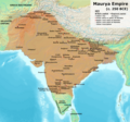
Skeda:Maurya Empire, c.250 BCE 2.png

Page contents not supported in other languages.
Nga Wikipedia, enciklopedia e lirë

Dokument origjinal((përmasa 1.200 × 1.121 px, madhësia skedës: 2,26 MB, lloji MIME: image/png))

Kjo skedë është prej Wikimedia Commons dhe mund të përdoret nga projekte të tjera. Përshkrimi në këtë skedë në këtë faqe nuk është treguar më poshtë. Shko tek faqja përshkruese në Commons Shko tek faqja përshkruese në Commons

Përmbledhje

Përshkrimi
English: Note: This was the standard "textbook" map of the Maurya Empire. Historians are now arguing that the Maurya Empire did not include large parts of India, which were controlled by autonomous tribes. For such a map, see File:Maurya Empire, c.250 BCE.png.
Alternative map of Maurya Empire

Boundaries are based on Charles Joppen Historical Atlas of India (1907), see File:India_in_250_B._C.jpg.

Other Sources:

Other sources:

  • Grainger, John D. (1990, 2014). Seleukos Nikator: Constructing a Hellenistic Kingdom. Routledge.
  • Keay, John (2000). India, a History. New York: Harper Collins Publishers.
  • Kulke, H.; Rothermund, D. (2004). A History of India, 4th, Routledge.
  • Puri, Baji Nath (1996). Buddhism in Central Asia. Delhi: Motilal Banarsidass.
  • Raychaudhuri, H. C.; Mukherjee, B. N. (1996). Political History of Ancient India: From the Accession of Parikshit to the Extinction of the Gupta Dynasty. Oxford University Press.
  • Stein, Burton (1998). A History of India (1st ed.), Oxford: Wiley-Blackwell.

Notes:

  • Sri Lanka and the southernmost parts of India (modern Tamil Nadu and Kerala) remained independent, despite the diplomacy and cultural influence of their larger neighbor to the north (Schwartzberg 1992, p. 18; Kulke & Rothermund 2004, p. 68).
  • The account of Strabo indicates that the western-most territory of the empire extended from the southeastern Hindu Kush, through the region of Kandahar, to coastal Baluchistan south of that (Raychaudhuri & Mukherjee 1996, p. 594).
  • The claim that Aria/Herat was one of the provinces (alongside Arachosia, Gedrosia, and Paropamisadae) ceded by Seleucus to Chandragupta Maurya is often repeated, but Aria (modern Herat) "has been wrongly included in the list of ceded satrapies by some scholars [...] on the basis of wrong assessments of the passage of Strabo [...] and a statement by Pliny." (Raychaudhuri & Mukherjee 1996, p. 594). Seleucus "must [...] have held Aria", and furthermore, his "son Antiochos was active there fifteen years later." (Grainger 2014, p. 109).
  • "The region of Aria is definitely known to have been Seleucid under Seleucus I and Antiochus I as it definitely was after Antiochus III's great campaign in the east against the Parthians and Bactrians. [...] There is no evidence whatever that it did not remain Seleucid, like Drangiana, with which it is linked by easy routes." -Susan M. Sherwin-White and Amélie Kuhrt (1993) From Samarkhand to Sardis: A New Approach to the Seleucid Empire, University of California Press, pp.79-80.
  • It is recorded that Drangiana province continued to be in the Seleucids' hands, as per [1].
  • "Desert of Gedrosia [...] was left an unclaimed wilderness." —Kosmin, Paul J. (2014), The Land of the Elephant Kings Space, Territory, and Ideology in the Seleucid Empire, Harvard University Press, p.16
  • Schwartzberg (p. 18) speculates about the Buddhist culture and Kharosthi inscriptions/manuscripts found in Khotan, but these texts from Khotan, Turfan, and Tajikstan have all been shown to be later than the 1st century BCE (Puri, p. 185).
Data
Burimi Punë e juaja
Autori Avantiputra7

Licencim

Unë, krijuesi i kësaj pune, e publikoj këtu në bazë të licensës në vijim:
w:sq:Creative Commons
atribuim share alike
Je i lirë të:
  • ta shpërndani – ta kopjoni, rishpërndani dhe përcillni punën
  • t’i bëni “remix” – të përshtatni punën
Sipas kushteve të mëposhtme:
  • atribuim – Duhet t’i jepni meritat e duhura, të siguroni një lidhje për tek licenca dhe të tregoni nëse janë bërë ndryshime. Këtë mund ta bëni në ndonjë mënyrë të arsyeshme, por jo në ndonjë mënyrë që sugjeron se licencuesi ju del zot juve apo përdorimit tuaj.
  • share alike – Nëse bëni një “remix”, e shndërroni, ose ndërtoni duke u bazuar te materiali, duhet t’i shpërndani kontributet tuaja sipas të njëjtës licencë ose një të tille të përputhshme me origjinalen.

Captions

Add a one-line explanation of what this file represents

Items portrayed in this file

përshkruan

Maurya empire anglisht

3 korrik 2014

Historiku skedës

Shtypni mbi një datë/kohë për ta parë skedën siç ishte atëherë.

(më të rinj | më të vjetër) Shikoni (10 më të reja) () (10 | 20 | 50 | 100 | 250 | 500).
Data/KohaMiniaturëPërmasatPërdoruesiKoment
e tanishme27 qershor 2024 10:27Miniaturë për versionin duke filluar nga 27 qershor 2024 10:271.200 × 1.121 (2,26 MB)Avantiputra7Reverted to version as of 11:01, 30 April 2024 (UTC) - vandalism
19 qershor 2024 10:52Miniaturë për versionin duke filluar nga 19 qershor 2024 10:521.200 × 1.121 (2,18 MB)Chakravartin1929Reverted to version as of 07:37, 14 April 2024 (UTC) This version is not even based on joppen's map. It's westernmost lands clearly dont match with that of joppen's map hence reverting to this.
30 prill 2024 13:01Miniaturë për versionin duke filluar nga 30 prill 2024 13:011.200 × 1.121 (2,26 MB)Avantiputra7western borders: see talk page
16 prill 2024 06:37Miniaturë për versionin duke filluar nga 16 prill 2024 06:371.200 × 1.121 (2,26 MB)Avantiputra7Reverted to version as of 11:12, 5 April 2024 (UTC) - vandalism
14 prill 2024 09:37Miniaturë për versionin duke filluar nga 14 prill 2024 09:371.200 × 1.121 (2,18 MB)Layman7676Reverted to version as of 11:12, 4 April 2024 (UTC) The map you are publishing isn't based on wha vincient Arthur really said.
5 prill 2024 13:12Miniaturë për versionin duke filluar nga 5 prill 2024 13:121.200 × 1.121 (2,26 MB)Avantiputra7Reverted to version as of 08:27, 3 April 2024 (UTC) - vandalism
4 prill 2024 13:12Miniaturë për versionin duke filluar nga 4 prill 2024 13:121.200 × 1.121 (2,18 MB)Chakravartin1929Reverted to version as of 05:41, 26 March 2024 (UTC) This is the true map. It depicts The mauryan map accurately.
3 prill 2024 10:27Miniaturë për versionin duke filluar nga 3 prill 2024 10:271.200 × 1.121 (2,26 MB)Avantiputra7Reverted to version as of 11:06, 3 March 2024 (UTC)
26 mars 2024 07:41Miniaturë për versionin duke filluar nga 26 mars 2024 07:411.200 × 1.121 (2,18 MB)Chakravartin1929Reverted to version as of 09:06, 3 March 2024 (UTC)
3 mars 2024 13:06Miniaturë për versionin duke filluar nga 3 mars 2024 13:061.200 × 1.121 (2,26 MB)Avantiputra7Reverted to version as of 11:10, 29 January 2024 (UTC)
(më të rinj | më të vjetër) Shikoni (10 më të reja) () (10 | 20 | 50 | 100 | 250 | 500).

Këto faqe lidhen tek kjo skedë:

Përdorimi global i skedës

Kjo skedë përdoret nga Wiki të tjera në vijim:

Shikoni më shumë përdorim global të kësaj skede.

Metadata