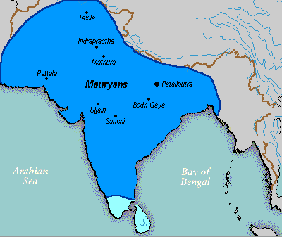
Skeda:Mauryan Empire Map.gif
Mauryan_Empire_Map.gif ((përmasa 400 × 337 px, madhësia skedës: 11 KB, lloji MIME: image/gif))
Historiku skedës
Shtypni mbi një datë/kohë për ta parë skedën siç ishte atëherë.
| Data/Koha | Miniaturë | Përmasat | Përdoruesi | Koment | |
|---|---|---|---|---|---|
| e tanishme | 25 mars 2016 02:16 |  | 400 × 337 (11 KB) | LouisAragon | rv, changes made by a banned user. |
| 23 prill 2007 03:14 |  | 400 × 337 (11 KB) | Jagged 85 | ||
| 14 dhjetor 2006 01:02 |  | 400 × 337 (11 KB) | Electionworld | {{ew|en|Vastu}} {{ShouldBeSVG}} ==Description== A poltical map of the Mauryan Empire, including notable cities, such as the capital Pataliputra, and site of the Buddha's enlightenment. ===Key=== Dark blue represents the extend of the Maur |
Lidhje skedash
Këto faqe lidhen tek kjo skedë:
Përdorimi global i skedës
Kjo skedë përdoret nga Wiki të tjera në vijim:
- Përdorimi në anp.wikipedia.org
- Përdorimi në bh.wikipedia.org
- Përdorimi në bn.wikipedia.org
- Përdorimi në bpy.wikipedia.org
- Përdorimi në ca.wikipedia.org
- Përdorimi në cs.wikipedia.org
- Përdorimi në cy.wikipedia.org
- Përdorimi në da.wikipedia.org
- Përdorimi në en.wikipedia.org
- Përdorimi në eo.wikipedia.org
- Përdorimi në fa.wikipedia.org
- Përdorimi në fi.wikipedia.org
- Përdorimi në fi.wikibooks.org
- Përdorimi në fr.wikipedia.org
- Përdorimi në gu.wikipedia.org
- Përdorimi në he.wikipedia.org
- Përdorimi në hi.wikipedia.org
- Përdorimi në it.wikipedia.org
- Përdorimi në ka.wikipedia.org
- Përdorimi në ko.wikipedia.org
- Përdorimi në la.wikipedia.org
- Përdorimi në lt.wikipedia.org
- Përdorimi në lv.wikipedia.org
- Përdorimi në ml.wikipedia.org
- Përdorimi në mr.wikipedia.org
- Përdorimi në ne.wikipedia.org
- Përdorimi në nl.wikipedia.org
Shikoni më shumë përdorim global të kësaj skede.


