
Skeda:Serbia-WW1-4.jpg
Madhësia e këtij shikimi: 799 × 271 pixel. Rezolucione të tjera: 320 × 109 pixel | 1.023 × 347 pixel.
Dokument origjinal ((përmasa 1.023 × 347 px, madhësia skedës: 99 KB, lloji MIME: image/jpeg))
| Kjo skedë është prej Wikimedia Commons dhe mund të përdoret nga projekte të tjera. Përshkrimi në këtë skedë në këtë faqe nuk është treguar më poshtë. | Shko tek faqja përshkruese në Commons |

|
This map has been uploaded by Electionworld from en.wikipedia.org to enable the |
Përmbledhje
| Përshkrimi |
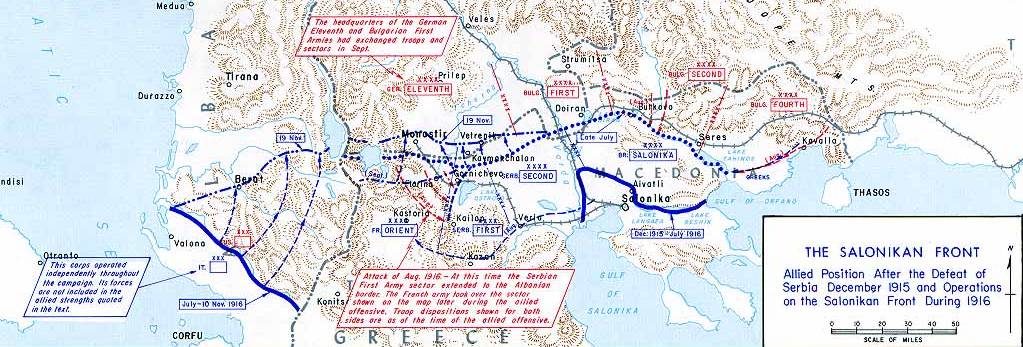
English: Operations at the border of Greece and Serbia, 1916.
his map was created by the Department of Military Art and Engineering, at the U.S. Military Academy (West Point). The initial version was created under the supervision of General Vincent Esposito in 1959. It is now available on the West Point |
||||||
| Data | |||||||
| Burimi | West Point | ||||||
| Autori | General Vincent Esposito | ||||||
| Leja (Ripërdor këtë skedë) |
|
||||||
| Versione tjera |
  |
||||||

Historiku skedës
Shtypni mbi një datë/kohë për ta parë skedën siç ishte atëherë.
| Data/Koha | Miniaturë | Përmasat | Përdoruesi | Koment | |
|---|---|---|---|---|---|
| e tanishme | 21 dhjetor 2006 23:55 | 1.023 × 347 (99 KB) | Electionworld | {{ew|en|Cglassey}} == Summary == Operations at the border of Greece and Serbia, 1916. his map was created by the Department of Military Art and Engineering, at the U.S. Military Academy (West Point). The initial version was created under the supervision |
Lidhje skedash
Këto faqe lidhen tek kjo skedë:
Përdorimi global i skedës
Kjo skedë përdoret nga Wiki të tjera në vijim:
- Përdorimi në ar.wikipedia.org
- Përdorimi në azb.wikipedia.org
- Përdorimi në az.wikipedia.org
- Përdorimi në be-tarask.wikipedia.org
- Përdorimi në be.wikipedia.org
- Përdorimi në bg.wikipedia.org
- Përdorimi në bs.wikipedia.org
- Përdorimi në ca.wikipedia.org
- Përdorimi në de.wikipedia.org
- Përdorimi në el.wikipedia.org
- Përdorimi në en.wikipedia.org
- History of modern Macedonia (Greece)
- Maurice Sarrail
- Macedonian front
- Battle of Doiran (1917)
- Greece during World War I
- Monastir offensive
- Autonomous Province of Korçë
- Bulgarian occupation of Albania
- World War I in Albania
- Battle of the Crna Bend (1917)
- User:GerardM/Battles including the Ottoman Empire
- User:Falcaorib
- User:BoDr12/sandbox
- Përdorimi në es.wikipedia.org
- Përdorimi në fa.wikipedia.org
- Përdorimi në fr.wikipedia.org
- Përdorimi në he.wikipedia.org
- Përdorimi në hr.wikipedia.org
- Përdorimi në hu.wikipedia.org
Shikoni më shumë përdorim global të kësaj skede.