
Skeda:Oise department relief location map.jpg
Madhësia e këtij shikimi: 780 × 599 pixel. Rezolucione të tjera: 313 × 240 pixel | 625 × 480 pixel | 1.000 × 768 pixel | 1.280 × 983 pixel | 1.446 × 1.111 pixel.
Dokument origjinal ((përmasa 1.446 × 1.111 px, madhësia skedës: 349 KB, lloji MIME: image/jpeg))
| Kjo skedë është prej Wikimedia Commons dhe mund të përdoret nga projekte të tjera. Përshkrimi në këtë skedë në këtë faqe nuk është treguar më poshtë. | Shko tek faqja përshkruese në Commons |
Përmbledhje
| Camera location | | View this and other nearby images on: OpenStreetMap |
|---|
| Përshkrimi |
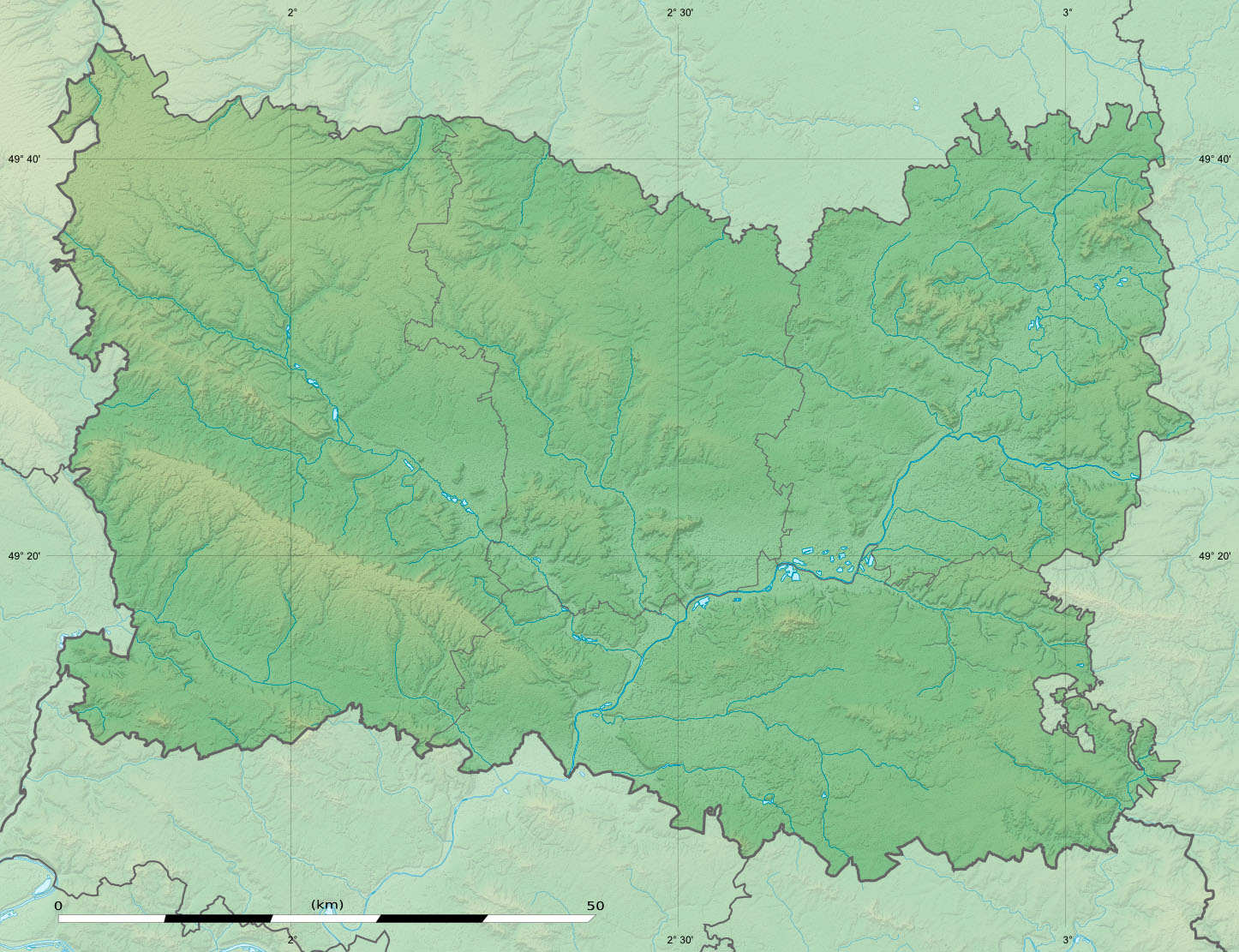
English: Blank physical map of the department of Oise, France, as in December 2014, for geo-location purpose, with distinct boundaries for regions, departments and arrondissements.
Français : Carte physique vierge du département de l'Oise, France, tel qu'en décembre 2014, destinée à la géolocalisation, avec limite distincte des régions, départements et arrondissements. Scales:
Equirectangular projection, WGS84 datum
Geographic limits of the map:
|
||
| Data | |||
| Burimi |
Punë e juaja
|
||
| Autori | Eric Gaba (Sting - fr:Sting) | ||
| Leja (Ripërdor këtë skedë) |
|
||
| Versione tjera |
|

Licencim
Eric Gaba, Wikimedia Commons user Sting, krijuesi i kësaj pune, e publikon këtu në bazë të licensës në vijim:
Kjo skedë licencohet sipas Creative Commons Attribution-Share Alike 3.0 Unported.
Atribuim: Eric Gaba, Wikimedia Commons user Sting
- Je i lirë të:
- ta shpërndani – ta kopjoni, rishpërndani dhe përcillni punën
- t’i bëni “remix” – të përshtatni punën
- Sipas kushteve të mëposhtme:
- atribuim – Duhet t’i jepni meritat e duhura, të siguroni një lidhje për tek licenca dhe të tregoni nëse janë bërë ndryshime. Këtë mund ta bëni në ndonjë mënyrë të arsyeshme, por jo në ndonjë mënyrë që sugjeron se licencuesi ju del zot juve apo përdorimit tuaj.
- share alike – Nëse bëni një “remix”, e shndërroni, ose ndërtoni duke u bazuar te materiali, duhet t’i shpërndani kontributet tuaja sipas të njëjtës licencë ose një të tille të përputhshme me origjinalen.
Historiku skedës
Shtypni mbi një datë/kohë për ta parë skedën siç ishte atëherë.
| Data/Koha | Miniaturë | Përmasat | Përdoruesi | Koment | |
|---|---|---|---|---|---|
| e tanishme | 27 dhjetor 2014 04:38 | | 1.446 × 1.111 (349 KB) | Sting | == {{int:filedesc}} == {{Location|49|24|00|N|02|25|30|E|scale:500000}} {{Information |Description={{en|Blank physical map of the department of Oise, France, as in December 2014, for geo-location purpose, with distinct boundar... |
Lidhje skedash
Këto faqe lidhen tek kjo skedë:
Përdorimi global i skedës
Kjo skedë përdoret nga Wiki të tjera në vijim:
- Përdorimi në als.wikipedia.org
- Përdorimi në de.wikipedia.org
- Përdorimi në eo.wikipedia.org
- Përdorimi në fr.wikipedia.org
- Oise (département)
- Compiègne
- Beauvais
- Ully-Saint-Georges
- Apremont (Oise)
- Creil
- Clermont (Oise)
- Gondreville (Oise)
- Chantilly
- Oudeuil
- Chaumont-en-Vexin
- Éragny-sur-Epte
- Bailleval
- Noyon
- Vendeuil-Caply
- Beauvoir (Oise)
- Breteuil (Oise)
- Noyers-Saint-Martin
- Ansauvillers
- Bacouël
- Montagny-en-Vexin
- Forêt de Retz
- Grandvilliers (Oise)
- Crèvecœur-le-Grand
- Gouvieux
- Monchy-Saint-Éloi
- Ermenonville
- Nanteuil-le-Haudouin
- Saint-Martin-aux-Bois
- Ville (Oise)
- Saint-Arnoult (Oise)
- Feigneux
- Ravenel
- Ons-en-Bray
- Orrouy
- Rethondes
- Aumont-en-Halatte
- Verberie
- Coye-la-Forêt
- Lamorlaye
- Avilly-Saint-Léonard
Shikoni më shumë përdorim global të kësaj skede.