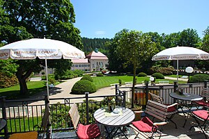
Bad Elster
komunë në Gjermani
emri zyrtar
Bad Elster
emërtimi në gjuhën amë
Bad Elster
shqiptimi i audios:
IPA transcription: baːt ˈɛlstɐ
emër i shkurtër
e vendosur në entitetin territorial administrativ të
Vogtlandkreis
e vendosur në zonën kohore
UTC+02:00
e vlefshme në periudhën: Llogaritja verore e kohës
koordinatat
popullsia
3.644[16]
metoda e përcaktimit: statistical updating
male population: 1.729
female population: 1.915
data: 31 dhjetor 2022
lartësia mbidetare
546 metër
trupi administrativ i binjakëzuar
Bad Waldsee
kufizohet me
Aš
Hranice
sipërfaqja
kodi postar
08645
webfaqja zyrtare
https://badelster.de/
gjuha e veprës ose emrit: gjermanisht
përshkruar nga burimi
Fjalori Enciklopedik Brockhaus dhe Efron
deklarata është subjekt i: Q24506613
Desktop Encyclopedic Dictionary
deklarata është subjekt i: Q86854863
Great Soviet Encyclopedia (1926–1947)
deklarata është subjekt i: Q106629682
Small Brockhaus and Efron Encyclopedic Dictionary
deklarata është subjekt i: Q24734712
Album der Schlösser und Rittergüter im Königreiche Sachsen V. Section
deklarata është subjekt i: Elster
data: 1859
Encyclopædia Britannica 11th edition
deklarata është subjekt i: 1911 Encyclopædia Britannica/Elster
prefiksi telefonik lokal
037437
kodi i targës
V
kategoria në Commons
Bad Elster
kategoria kryesore
Category:Bad Elster
category for the view of the item
Category:Views of Bad Elster
Reference
- ^ Freebase Data Dumps, 28 tetor 2013
- ^ https://service.unece.org/trade/locode/de.htm
- ^ n83030315, 22 prill 2024, Library of Congress Authorities
- ^ GeoNames
- ^ Flickr Shapefiles Public Dataset 2.0
- ^ archINFORM, https://www.archinform.net/service/wd_aiort.php, 5 gusht 2018
- ^ Datoteka e Autoritetit Virtual Ndërkombëtar, 2 gusht 2015
- ^ museum-digital
- ^ Datoteka e Autoritetit Virtual Ndërkombëtar, 6 mars 2019
- ^ cf94ad29-8558-4e81-8d2b-1292b5eb02af, 22 dhjetor 2020, Bibliography of the History of the Czech Lands, ge755473
- ^ National Library of Israel Names and Subjects Authority File
- ^ http://digital.slub-dresden.de/id516033158
- ^ directory of German Library Codes
- ^ archINFORM, 6 gusht 2018, 4463
- ^ GeoNames, 2953509
- ^ register of German municipalities (2022), 7 tetor 2023
- ^ 10 mars 2019, https://web.archive.org/web/20190310200237/https://www.destatis.de/DE/ZahlenFakten/LaenderRegionen/Regionales/Gemeindeverzeichnis/Administrativ/Archiv/GVAuszugQ/AuszugGV4QAktuell.xlsx?__blob=publicationFile, Federal Statistical Office, https://www.destatis.de/DE/ZahlenFakten/LaenderRegionen/Regionales/Gemeindeverzeichnis/Administrativ/Archiv/GVAuszugQ/AuszugGV4QAktuell.html, Alle politisch selbständigen Gemeinden mit ausgewählten Merkmalen am 31.12.2018 (4. Quartal), 10 mars 2019


