
Garidech
Gardheshë | |
|---|---|
Komunë | |
 Pamje e përgjithshme e Gardheshës | |
.svg) Stema | |
Location of Gardheshë Lua error te Moduli:Infobox_mapframe te rreshti 86: bad argument #1 to 'sqrt' (number expected, got nil). | |
.svg) Garidech (Earth) | |
| Koordinatat: 43°42′32″N 1°33′42″E / 43.7089°N 1.5617°E | |
| Vendi | Franca |
| Rajoni | Occitania |
| Departamenti | Haute-Garonne |
| Qarku | Toulouse |
| Kantoni | Pechbonnieu |
| Ndërkomunalitet | Coteaux du Girou |
| Qeveria | |
| • Kryetari (2020–2026) | Christian Ciercóles[1] |
| Sipërfaqja 1 | 7.110 km2 (2.745 sq mi) |
| Popullsia (Janar 2020) | 1.918 |
| • Dendësia | 270/km2 (700/sq mi) |
| Zona kohore | UTC+01:00 (CET) |
| • Verës (DST) | UTC+02:00 (CEST) |
| INSEE/Kodi postar | 31212 /31380 |
| Lartësia | 132–214 m (433–702 ft) (avg. 190 m or 620 ft) |
| 1 French Land Register data, which excludes lakes, ponds, glaciers > 1 km2 (0.386 sq mi or 247 acres) and river estuaries. | |
Garidech ( shqiptimi frëngjisht: [ɡaʁidɛʃ] ; Ocitanisht: Garidèit ; Shqip: Gardhesha) është një komunë në departamentin Haute-Garonne në Francën jugperëndimore.
Popullatë
[Redakto | Redakto nëpërmjet kodit]
| ||||||||||||||||||||||||||||||||||||||||||
Monumentet
[Redakto | Redakto nëpërmjet kodit]-
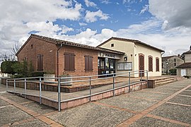 Bashkia
 -
 Përkujtimorja
 -
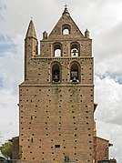
 Kisha Saint-Jean-Baptiste
 -
 Kullë
Kullë -
 Shkollë fillore


- ^ "Répertoire national des élus: les maires". data.gouv.fr, Plateforme ouverte des données publiques françaises (në frëngjisht). 2 dhjetor 2020.