
Gratentour
Gratenas | |
|---|---|
Komunë | |
 Pamje e përgjithshme e Gratenasit | |
.svg) Stema | |
Location of Gratenas Lua error te Moduli:Infobox_mapframe te rreshti 86: bad argument #1 to 'sqrt' (number expected, got nil). | |
.svg) Gratentour (Earth) | |
| Koordinatat: 43°43′19″N 1°25′56″E / 43.7219°N 1.4322°E | |
| Vendi | Franca |
| Rajoni | Occitania |
| Departamenti | Haute-Garonne |
| Qarku | Toulouse |
| Kantoni | Castelginest |
| Ndërkomunalitet | Toulouse Métropole |
| Qeveria | |
| • Kryetari (2020–2026) | Patrick Delpech[1] |
| Sipërfaqja 1 | 4.090 km2 (1.579 sq mi) |
| Popullsia (Janar 2020) | 4.501 |
| • Dendësia | 1,100/km2 (2,900/sq mi) |
| Zona kohore | UTC+01:00 (CET) |
| • Verës (DST) | UTC+02:00 (CEST) |
| INSEE/Kodi postar | 31230 /31150 |
| Lartësia | 123–194 m (404–636 ft) (avg. 170 m or 560 ft) |
| 1 French Land Register data, which excludes lakes, ponds, glaciers > 1 km2 (0.386 sq mi or 247 acres) and river estuaries. | |
Gratentour (shqiptimi frëngjisht: [ɡʁatɛ̃tuʁ] Ocitanisht: Gratentorn ; Shqip: Gratenas) është një komunë në departamentin Haute-Garonne në Francën jugperëndimore.
Popullsia
[Redakto | Redakto nëpërmjet kodit]
| ||||||||||||||||||||||||||||||
Monument
[Redakto | Redakto nëpërmjet kodit]-
 Bashkia
 -
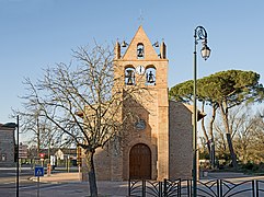
 Kisha Sainte Quitterie
 -
 Këmbanorja e kishës Sainte Quitterie


- ^ "Répertoire national des élus: les maires". data.gouv.fr, Plateforme ouverte des données publiques françaises (në frëngjisht). 2 dhjetor 2020.