Stampa:KUTIAIrani
Kjo është kutiza për artikulli Irani
جمهوری اسلامی ایران
(Jomhuri-ye Eslami-ye Iran) | |||||||||||||||||||||||||||||
| |||||||||||||||||||||||||||||
| Moto Kombëtare: Esteqlāl, āzādī, jomhūrī-ye eslāmī Per.:Pavarsia, Liria dhe Republika Islamike | |||||||||||||||||||||||||||||
 | |||||||||||||||||||||||||||||
Të dhëna tabelare
Stampa:Shtete
| |||||||||||||||||||||||||||||
Atlasi
[Redakto nëpërmjet kodit]Harta të përgjithëshme

|
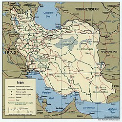
Map of Iran |

|
Map of Iran in Farsi |
|
Map of Iran |

|
Topographic map |

|
Provinces of Iran |

|
Counties of Iran |
Harta historike
Seksioni përmbanë harta historike të sipërfaqes së sotshme ku nodhet Iran (Persia) si dhe harta të vendeve në përbërje të së cilave ishte kjo sipërfaqe.

|
Fertile Crescent |

|
Akkadian Empire around 2000 BCE |

|
The Elamite Empire (2700-539 BCE) |

|
The Assyrian Empire in the 9th to 7th centuries BC |

|
Deportation of the Jews by the Assyrian Empire |

|
Neo-Assyrian Empire |

|
Urartu at its greatest extent in the time of Sarduris II, 743 BC |

|
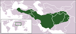
The Median Empire (728-550 BCE) |
|
Median Empire |
Persian Empire
[Redakto nëpërmjet kodit]
|
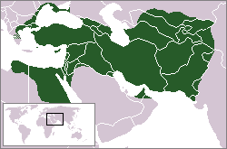
The Achaemid Empire (Persia (648–330 BCE) at its greatest extent |
|
The Persian Achaemenid Empire |

|
The Persian Achaemenid Empire |

|
The Persian Achaemenid Empire |
Macedonian Empire
[Redakto nëpërmjet kodit]
|
334-323 BCE: Macedonian Empire - occupying country ► Macedonian Empire |
| [[|border|250x400px]] | The Expedition of Alexander the Great 334-323 BCE |

|
The Expedition of Alexander the Great 334-323 BCE |

|
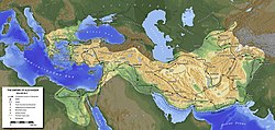
Map of the Empire of Alexander |
|
Map of the Empire of Alexander 334-323 BCE |

|
Map of the Empire of Alexander (Norwegian) |
The template itself
[Redakto nëpërmjet kodit]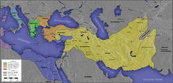
|
Hellenistic successor states: Kingdom of Ptolemy Kingdom of Cassander Kingdom of Lysimachus Kingdom of Seleucus Other states:
|

|
Map of the diadochs kingdoms (in french) |

|
Hellenistic world in 200 BCE |

|
Greco-Bactrian kingdom (250-125 BCE) |
Parthia
[Redakto nëpërmjet kodit]
|
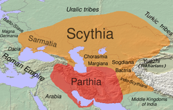
The Parthian empire |
| The Parthian Empire (250 BCE-226 CE) |
|
Map of Parthia 100 BC |

|
Indo-Sassanide Empire |
|
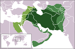
The Persian Sassanian Empire (226-650) in 602 to 629, Strokes: Under Sassanid military control. |

|
Sassanide Empire |

|
Sassanide Empire |

|
Expansion of the Caliphate: I: Muhammad; II: Abu Bakr; III: Omar and IV: Othman |

|
Age of the Caliphs |

|
Caliphate around 750 |
|
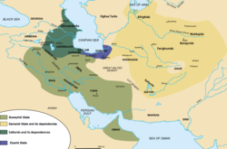
Iran around 1000 |

|
The Seljuq Empire 1037-1194 |
|
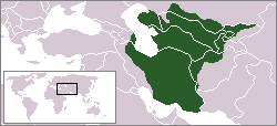
The Khwarezmid Empire around 1220 |
The template itself
[Redakto nëpërmjet kodit]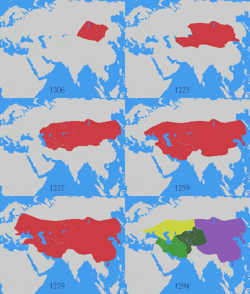
|
Map showing changes in borders of the Mongol Empire from founding by Genghis Khan in 1206, Genghis Khan's death in 1227 to the rule of Kublai Khan (1260–1294). (Uses modern day borders)
Mongol Empire
By 1294 the empire had split into: Empire of the Great Khan (Yuan Dynasty)
|

|
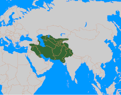
The Timurid Empire 1405 |
|
The Timurid Empire 1405 |
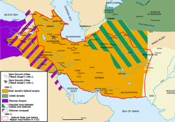
| The Persian Safavid Empire (1501-1722/1736) |
|
The Safavid Empire |
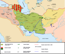
|
Iran around 1900 |
Old maps
This section hold copies of original general maps older than 70 years of this entry.
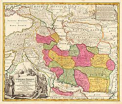
|
Map of Persia around 1700 |

|
A 1753 map by Robert De Vaugondy titled ESTATS DU GRAND-SEIGNEUR EN ASIE where the color yellow marks the Greater Persian territores. |

|
An 1808 British map of Persia. |
Ethno-linguistic maps
| [[|border|250x400px]] | People's of Iran |
| [[|border|250x400px]] | Ethnic Map of Iran |

|
Map of the Kurdish inhabited areas |

|
Languages |
| Skeda:Iranian languages area.png | The Iranian languages |
Other maps

|
Major crops |

|
Oil |

|
Nuclear program |

|
Railways |

|
Biotopes of Iran |

|
Biotopes of Iran |

|
Satellite map |
Shënime
[Redakto nëpërmjet kodit]Stampa:KUTIAAfganistani · Stampa:KUTIAArmenia · Stampa:KUTIAArabia Saudite · Stampa:KUTIAAzerbajxhani · Stampa:KUTIABahraini · Stampa:KUTIABangladeshi · Stampa:KUTIABrunei · Stampa:KUTIAButania · Stampa:KUTIABirmania · Stampa:KUTIAEmiratet e Bashkuara Arabe · Stampa:KUTIAFilipinet · Stampa:KUTIAGjeorgjia · Stampa:KUTIAIndia · Stampa:KUTIAIndonezia · Stampa:KUTIAIraku · Stampa:KUTIAIrani · Stampa:KUTIAIzraeli · Stampa:KUTIAJaponia · Stampa:KUTIAJemeni · Stampa:KUTIAJordania · Stampa:KUTIAKamboxhia · Stampa:KUTIAKatar · Stampa:KUTIAKazakistani · Stampa:KUTIAKina · Stampa:KUTIAKirgistani · Stampa:KUTIAKoreja Jugore · Stampa:KUTIAKoreja Veriore · Stampa:KUTIAKuvajti · Stampa:KUTIALaosi · Stampa:KUTIALibani · Stampa:KUTIAMalajzia · Stampa:KUTIAMaldives · Stampa:KUTIAMongolia · Stampa:KUTIANepali · Stampa:KUTIAOmani · Stampa:KUTIAPakistani · Stampa:KUTIAQipro · Rep. Kineze Tajvan · Stampa:KUTIARusia · Stampa:KUTIAShiri Lanka · Stampa:KUTIASingapuri · Stampa:KUTIASiria · Stampa:KUTIATailanda · Stampa:KUTIATaxhikistani · Stampa:KUTIATimori Lindor · Stampa:KUTIATurkmenistani · Stampa:KUTIATurqia · Stampa:KUTIAUzbekistani · Stampa:KUTIAVietnami


