
Skeda:Noord-Brabant position.svg

Size of this PNG preview of this SVG file: 200 × 236 pixel. Rezolucione të tjera: 203 × 240 pixel | 407 × 480 pixel | 651 × 768 pixel | 868 × 1.024 pixel | 1.736 × 2.048 pixel.
Dokument origjinal (skedë SVG, fillimisht 200 × 236 pixel, madhësia e skedës: 158 KB)
| Kjo skedë është prej Wikimedia Commons dhe mund të përdoret nga projekte të tjera. Përshkrimi në këtë skedë në këtë faqe nuk është treguar më poshtë. | Shko tek faqja përshkruese në Commons |
Përmbledhje
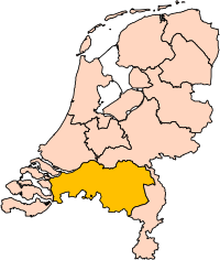
| Përshkrimi | Location of the province of Noord-Brabant (North Brabant) in the Netherlands. |
| Data | |
| Burimi | Own work, based on freely available GIS data |
| Autori | User:Mtcv |
| Leja (Ripërdor këtë skedë) |
Data: attribution required; my work: PD |
| Versione tjera | I attempted to make an svg version of Image:Noord Brabant-Position.png (with less simplified boundaries) |
Clickable version

Licencim

|
Krijuesi i kësaj skede, Centraal Bureau voor de Statistiek, lejon këdo ta përdorë për çdo qëllim, me kusht që krijuesi është i atribuar si duhet. Rishpërndarja, puna derivative, përdorimi komercial, dhe të gjitha përdorimet janë të lejuara. |
Atribuim:
|
| Annotations | This image is annotated: View the annotations at Commons |


Historiku skedës
Shtypni mbi një datë/kohë për ta parë skedën siç ishte atëherë.
| Data/Koha | Miniaturë | Përmasat | Përdoruesi | Koment | |
|---|---|---|---|---|---|
| e tanishme | 2 mars 2019 19:20 | | 200 × 236 (158 KB) | Thayts | update |
| 3 tetor 2006 02:49 |  | 200 × 236 (158 KB) | Mtcv | {{Information| |Description=Location of the province of Noord-Holland (North Holland) in the Netherlands. |Source=Own work, based on freely available GIS data |Date=2006-10-03 |Author=User:Mtcv |Permission=Data: attribution required; my work: PD |othe |
Lidhje skedash
Këto faqe lidhen tek kjo skedë:
- 's-Hertogenbosch
- Aalburg
- Alphen-Chaam
- Asten
- Baarle-Nassau
- Bergeijk
- Bergen op Zoom
- Bernheze
- Best (Holandë)
- Bladel
- Boekel
- Boxmeer
- Boxtel
- Breda (Holandë)
- Cranendonck
- Cuijk
- Deurne
- Dongen
- Drimmelen
- Eersel
- Eindhoven
- Etten-Leur
- Geertruidenberg
- Geldrop-Mierlo
- Gemert-Bakel
- Gilze en Rijen
- Goirle
- Grave (Holandë)
- Haaren
- Halderberge
- Heeze-Leende
- Helmond
- Heusden
- Hilvarenbeek
- Laarbeek
- Landerd
- Lith
- Loon op Zand
- Maasdonk
- Mierlo
- Mill en Sint Hubert
- Moerdijk
- Nuenen, Gerwen en Nederwetten
- Oirschot
- Oisterwijk
- Oosterhout
- Oss (Holandë)
- Ravenstein
- Reusel-De Mierden
- Roosendaal
- Rucphen
- Schijndel
- Sint-Michielsgestel
- Sint-Oedenrode
- Sint Anthonis
- Someren
- Son en Breugel
- Steenbergen
- Tilburg
- Uden
- Valkenswaard
- Veghel
- Veldhoven
- Vught
- Waalre
- Waalwijk
- Werkendam
- Woensdrecht
- Woudrichem
- Zundert
- Stampa:Provinca Brabanta Veriore
Përdorimi global i skedës
Kjo skedë përdoret nga Wiki të tjera në vijim:
- Përdorimi në ar.wikipedia.org
- شمال بربنت
- آيندهوفن
- بريدا
- بارله ناساو
- تيلبورخ
- سيرتوخيمبوس
- قالب:بلديات شمال برابنت
- آلبورخ
- ألفن- كام
- أستن
- بيرخ آيك
- فيلدهوفن
- بيرخن أوب زووم
- بيرنهيزه
- بيست (هولندا)
- بلادل
- بوكل
- بوكسمير
- بوكستل
- كرانندونك
- كاوك
- دورنه
- دونجن
- دريميلين
- إيرسل
- إيتن- لور
- خيرتراودنبيرخ
- خيلدروب- ميرلو
- خيميرت- باكل
- خيلزه آن راين
- خورلا
- خرافه (هولندا)
- هارن (شمال برابنت)
- هالدربيرخه
- هيزه- لينده
- هيلموند
- هوسدن
- هيلفارينبيك
- لاربيك
- لانديرد
- لوب أوب زند
- مل آن سينت هوبرت
- موردايك
- نونن (خيرفن آن نيدرفيتن)
- أويرشخوت
- أويسترفايك
- أوسترهاوت
- أوس (هولندا)
- روسل- دي ميردن
- روسيندال
Shikoni më shumë përdorim global të kësaj skede.